
High Atlas
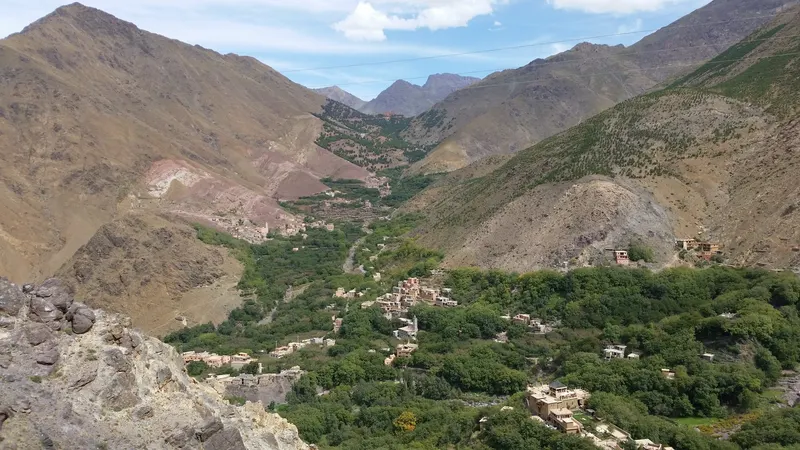
Imlil or Aït Bouguemez: begin with a named mountain base, its village setting and the kind of stay you want, before considering a trek.
In this guide
Overview: choose a place within the mountains
“The High Atlas” is a region to narrow down, rather than a single stop to book. This introduction considers two possibilities: Imlil, associated with Toubkal, and the Aït Bouguemez Valley in the Azilal area. Begin with one named base and a reason for staying there. A village stay, a particular walking route and a summit attempt are different plans; choosing the first does not commit you to the others.
Experiences around Imlil: look at the village first
The Marrakech-Safi tourism council describes Imlil’s earthen buildings and agricultural terraces alongside its association with Toubkal. Those features offer an interest in the inhabited mountain landscape itself. When discussing a stay, ask what you can see from the property and which village visits can be arranged for your dates. A Toubkal ascent requires its own specialist planning.
Aït Bouguemez: a valley with several points of interest
The national tourism office places Aït Bouguemez among the High Atlas landscapes of the Azilal region and names the Arous gorges in its valley introduction. Use the valley name to begin research, then identify the actual village and accommodation you would stay in. A photograph captioned “Aït Bouguemez” does not show how close a property is to the particular landscape you want to visit. Ask locally about the gorges before planning an outing.
Back to contentsLocal context: buildings belong to a working landscape
The Province d’Azilal highlights Aït Bouguemez’s grouped villages and the region’s collective granaries, stone and earth architecture. This gives a stay another focus beyond mountain views: how homes, storage and shared spaces fit together. Ask a host or guide which buildings can be visited and what their uses are. Keep permission specific to the building and the people concerned; neither a heritage label nor a view from the road makes a home open to visitors.
Ibaqualliwn: read a landscape through its footprints
Aït Bouguemez has a geological story as well as an agricultural one. The M’Goun Geopark identifies dinosaur footprints at Ibaqualliwn, including three-toed tracks attributed to theropods and oval impressions attributed to sauropods. These are traces of animals moving across an ancient surface, rather than a display of reconstructed skeletons. The difference in footprint shapes gives you something concrete to look for in the geopark’s interpretation. If this is a reason for choosing the valley, ask locally about the site’s current visitor arrangements and interpretation.
Getting around: connect the named stay to the rest of the trip
Request the exact accommodation location, vehicle meeting point and final approach to the door. Confirm who provides each transfer and the arrangements for returning or continuing onward. If an outing is included in a stay, have it described separately from the room booking, with its meeting point, scope and cancellation terms. The places named here are subjects for a visit, not verified walking or summit routes. Confirm current roads, paths, site access and the suitability of any outing with the relevant local providers before fixing the surrounding nights.
Back to contentsNext steps: give one base its own time
As a starting outline, two nights in one confirmed base would leave a full day between arrival and departure. Choose an outing only after establishing what fits that day. Compare that stay with the time you would otherwise spend in Marrakech or on the coast. Do not combine Imlil and Aït Bouguemez into one stop called “the Atlas”: each needs its own location and transfer research. If the experience you want is rocky desert scenery or sand dunes, use the desert guide to distinguish those choices before extending the route.
Sources
Each reference lists the information it supports and the date it was checked.
- Marrakech-Safi Regional Tourism Council: Imlil
Imlil’s mountain-village setting, association with Toubkal, earthen buildings and agricultural terraces. Check current access and conditions before travelling.
Checked
- Moroccan National Tourist Office: nature in Azilal
Aït Bouguemez Valley in the High Atlas/Azilal setting and the named Arous gorges. Does not verify a route, activity, present access or suitability.
Checked
- Province d’Azilal: tourism and architectural heritage
Aït Bouguemez’s grouped villages and the region’s collective granaries, stone and earth architecture. Check current access separately.
Checked
- M’Goun Geopark: Ibaqualliwn dinosaur footprints
Identifies three-toed theropod and oval sauropod footprints at Ibaqualliwn. Check present visitor access before planning an outing.
Checked
- M’Goun Geopark: Ibaqualliwn geosite 13
Locates the Ibaqualliwn footprint site in Aït Bouguemez and identifies theropod and sauropod tracks. Excludes ages, coordinates, distances, hiking time, difficulty and current access.
Checked
Something needs attention? Read about corrections.
Back to the start of this guide